Sunday, August 25, 2024

MY EPIC ROAD TRIP: BAD DECISIONS MAKE GOOD STORIES, CHAPTER 5

Still in Vermont on my epic MA-VT-NY-NY-VT-MA road trip -- 

I have a few more things that I want to see in Middlebury, Vermont, before I get on the road for New York's North Country. First stop is the post office to buy stamps and to mail the postcards. Yes, the postcards are old-school, but it's fun. I still have zero cell service and GPS, but I know the center of town well since I circled around it a half dozen times the day before when trying to find the Morgan Horse Farm. After the post office, I walk across the parking lot to a green space where there is a pedestrian bridge, an old stone mill, and a waterfall. 

Then, I prepare to head toward Crown Point, New York. This is where it gets tricky. A recent bout of hurricane fall-out has washed out the main road to get where I am going. There are two other ways to go, but route 125 is the easiest. Except ... the road forks in Middlebury, and there are ZERO signs as to which road I am on. I have to make an executive decision, then change my mind. Only problem is that now I am stuck on one-way roads heading out of town on the more difficult road (that would be simple if I had GPS and a decent map).

I get turned about for a short while until someone helps me out. I start traveling on route 74, which winds around and is through an area only cows could love because there is nothing but an occasional farm for miles and miles. My helper had suggested a cut-through road, which would've saved me about ten miles or so, but I am afraid at this point to veer off the numerical path. I find myself swearing a little bit at my phone and swearing a lot at myself for being a dope with no sense of direction. 

Right about the time I am cursing everything and everyone for my own idiocy, I come to the top of a rise and have the most incredible, fantastic, unbelievable views. 360 degrees of mountains and awe. Green Mountains behind me; Adirondack Mountains in front of me. 

It. Is. Amazing.

I go a little further in my quest to find my way back to the correct route when I pass a random school house on the top of a hill. Directly across the street is an amazing spread of land with a beautiful house and an even more gorgeous barn set up. As I pull over to take pictures, a motorcyclist (the first person I have encountered in about an hour) also pulls over and asks if I'm all right. I explain that I'm a teacher and have to get a picture of the school but thank him for stopping. It may be rare to see humans out here, but, when you do, they're darn nice people.

I get back on track and cross the first modern bridge I've seen in two days, the Lake Champlain Bridge that connects Chimney Point, Vermont, with Crown Point, New York. It's also under construction, much like the historic Quechee Bridge, and only one lane of traffic is being allowed at a time. I don't mind waiting. The bridge offers some impressive scenery. 

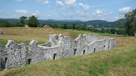
Once I cross the bridge, there is an old stone fort off to the right. It was built by the French in 1734 and taken over by the British in 1759. American colonists took over the fort in 1775 before it fell back into British hands in 1777. The ruins of the fort became property of New York state in 1910. The stone work is impressive, and there are masons here today working on repairs of one of the remaining parts of the fort. 

I can see a yellow bus in the parking lot. Of course there is a school bus. Educators are like fly-paper for children. When I was at a museum in North Carolina a few months back, there were three separate groups of sixth graders there on field trips. Naturally, this historical park will be full of children because why in the name of all things sane should a school teacher escape the yellow bus and minions even during summer break? It's a giant cosmic joke.

My next stop is the Champ Tote Board. There is tale in this part of the country of a giant sea monster named Champ, or Champy, that lives in the depths of Lake Champlain. I've crossed the lake dozens of times, and I always look for Champy, but I've never seen it. It's a fun reminder, though, that our local tall tale may actually be fact. I pull my car back on the road and stay alert as this area is notorious for speed traps, but, alas, not a cop in sight today.

Of course there isn't a police officer to assist because this is when disaster strikes. Remember a few weeks ago when I wrote to hold that thought about my car having 93,000 miles on it? Hold that thought a little longer and I'll explain it next blog.

Sunday, August 18, 2024

MY EPIC ROAD TRIP: BAD DECISIONS MAKE GOOD STORIES, CHAPTER 4

Epic journey through Vermont and New York (in case you forgot) . . .

Road Trip continued: I roll into Middlebury, Vermont, about two hours ahead of my worst-case scenario schedule. So far my driving plan has been reasonably straightforward, and I still have both cell phone GPS and an old TomTom GPS system making sure I'm going where I belong. 

All is right with the world for now.

My first Middlebury stop is the American Legion Post, where there is what Roadside Attractions website calls "Jet on a Stick." Middlebury was one of the Legion's first ever organizations, starting in 1919, but not at its current location. The A-4 Skyhawk jet was procured through a Marine who flew A-4s during the Vietnam War. My first reaction when I get out of the car is, "This is frakking cool!" The plane is on loan from both the Marine Corps Air Station and the US Naval Museum, and it has been "on a stick" for nearly twenty-five years. I think it's amazing, so I snap about a dozen photos.

My next stop is the Middlebury Art Museum. It's free and small enough to breeze through relatively quickly. It doesn't seem like much from the outside, but the very first thing I see is a small sculpture by Rodin. There's an Andy Warhol print, and an ancient Egyptian sarcophagus from about 664 BCE to 343 BCE. The top floor is inundated with ginormous papier-mache puppets. It takes me about twenty minutes to get through.

I glance at my phone and realize that I have time to fit in the UVM Morgan Horse Farm today. This is amazing! Until . . . it's not. Suddenly and without warning, pomp, nor fanfare, I entirely lose cell, internet, and all GPS. 

Even though I have rudimentary maps printed out, I cannot see the names of streets. That's all right. I'm an intelligent woman. I can follow street signs as well as anyone else. Except . . . Middlebury doesn't believe in clear street signs that point in the correct directions. Remember when I mentioned printed maps last week and wrote for readers to  hold that thought

Well, now is the beginning of the Great Middlebury Map Fiasco of 2024.

I know that the Morgan Horse Farm is less than four miles away, and I know the general direction, but the streets go to nowhere, or they have similar names, or they go only one way, or the signs point left and right and up and down all at the same time. I circle the area in my car for almost an hour, and drive miles and miles and miles out of my way and in giant geometric directions. An oval here, a square there, and, oh, look, I've just completed a dodecahedron. I ask a nice young couple for directions, but they're not locals. I ask another older couple, but they don't speak English, and my Spanish far exceeds my French. Finally, I see a young girl walking a dog. She directs me across the very cool Pulp Mill Covered Bridge, and I finally see a sign for the stables.

When I arrive at 2:43, I know there is one more tour at 3:00. There are some horses in the paddocks, but honestly, it is so bloody hot outside that the poor animals probably should be in the shade. Despite there being several cars at the facility, I am the only one signed up for a tour. I feel silly, and I explain to the young guide that I'm happy to wander around; they can keep my small tour fee as a donation. But, no, I get a private tour with a friendly apprentice, who apologizes because the horses have indeed been brought inside, which prevents decent photos. So, she walks me through the barn to meet the horses, and we talk about my limited but sufficient familiarity with the lineage and physical qualities of the Morgan horse breed.

Finally, I know the place will be closing soon, so I say my thanks. Oh, no, though, we are not quite finished. Annalise is heading to the foaling barn. Would I like to come meet the foals? Holy crap, yes, I would! We walk to the far barn where she swings the paddock gates wide open and invites me to walk across the huge empty (and poop-less -- absolutely spotless) area. She then invites me into the specialty building and introduces me to all six foals and mares and tells me each one's story.

It. Is. Phenomenal.

I head back to town, check into my hotel, then shower the entire steaming day off. Other than the door to my room being finicky (I open it once to check in and once when I leave so I don't get locked out), the only two flies are that the wi-fi is spotty so I am still in Cell Hell, and I forgot to bring stamps for the postcards. Luckily, there's a post office nearby that I can hit on my way out of town. Besides, I circled Middlebury so many times today, I am familiar enough with the town to find my own way.

Or, so I innocently believe. Next installment: You can't get there from here.

Sunday, August 11, 2024

MY EPIC ROAD TRIP: BAD DECISIONS MAKE GOOD STORIES, CHAPTER 3

{Continued saga of the epic road trip from Massachusetts to Vermont, to Plattsburgh, NY, to Syracuse, NY, through Albany, NY, back to Plattsburgh, NY, then back to Massachusetts -- Yes, It's a triangle+ of epic proportions, not a straight line, because somebody (me) feels a great need to explore areas of Vermont and New York that I have not been to yet.}

Day #1 - Everything is loaded into the car, my snacks and cooler are within easy reach at any and every stop, and my good camera is an arm's-length away. I'm full of confidence that everything, every single little thing, is going to go my way, exactly as planned, or better!

The first stop is a rest area. Unfortunately for me and everyone else who stops, we're about fifteen minutes too early to use the facilities. One hardy gentleman does his business in a porta-potty, throwing the door open afterward to exclaim, "It's not too bad in there compared to the other ones." His female companion and I glance at each other and shake our heads. I'm not against porta-potties; I use them whenever it's necessary. But, I'm reasonably close to civilization, so I opt for a quick few photos of the view and head back on the road. 

Quechee Gorge plunges about 165 feet with spectacular ledge views and a 1.3 mile trail along the Ottauquechee River. There's an amazing bridge that provides panoramic views without having to hike down and then back up again. Unfortunately, the bridge is reduced to one lane right now and is totally under construction. The view is not only obstructed; it is completely hidden by lumber. The bridge, a three-hinge steel deck arch, was constructed in 1911 as a railroad bridge. I'm deeply depressed that I am only able to snap pictures of the north side through a fence and from a trail through trees, but I'm thrilled the state is saving the bridge. I might have time to make the trek down and back into the gorge itself -- I've done it before -- but I'm wearing sandals, and it's already blast-furnace hot at 9:00 a.m. Maybe next time.

Due to the backed-up traffic crossing the construction zone, I accidentally miss the Quechee Covered Bridge, but I do manage to see the next three on my list: Taftsville, Middle, and Lincoln Covered Bridges. There are a couple of great spots to view the Taftsville Bridge, and it's the only one of the three that I get any decent shots of on the drive. 

I am about an hour ahead of my self-imposed schedule, which puts me at the base of Killington mountain mid-morning. I arrive at the Water Wheel Trading Post too late for their famous breakfast sandwich and too early to buy beer with a clear conscience. I stop anyway, grab some chocolate and a picture or two, and head toward my next stop.

Unfortunately, not all of Vermont is a quaint Hallmark movie, and Rutland is a perfect example. There are a couple of sculptures I'd like to see. One is Batman Meets Mr. Halloween, which I drive past getting to the artwork that I truly do want to see: a Steampunk locomotive made out of scrap. I'd like to exit my car and snap better photos, but this may not be the best idea with the train station parking lot under partial occupation and with active dirty deals taking place in the wide open light of day. Rutland has a relatively high crime rate, and I am a single old lady with a car full of goodies. Luckily, it starts to rain, which makes getting out of the car a dumb idea, anyway, and I use my camera from the comfort and safety of my vehicle (note the inspection sticker in the bottom right of the frame).

The second to last stop before I get to today's end point of Middlebury, is the New England Maple Syrup Museum. Yes, it's more store than artifact, but the place is charming. I join a couple from New York, and we sample some amazing local maple syrup. We all love the final one, a bourbon-barrel sample that is the best maple syrup I have ever tasted in my life. There is only one bottle left, and the other couple grabs it. I take my second favorite as a gift to my hosts, who always bring me New York maple syrup. I also spend a pretty penny on lots of other useless stuff because this shop has about a zillion things that I want to buy.

The last thing I need to see before rolling into today's ultimate destination is a huge

statue/sculpture named Queen Connie. Connie is a giant steel and concrete (aka "Connie") gorilla that is holding up an old Volkswagen Beetle. Her other arm is a large seat that people can sit in. (I do not in case I get stuck in it.). A few snapshots later, I wave goodbye to Queen Connie and continue up route 7, bringing me to another chapter of the blog, which will post next Sunday.

Don't worry, folks. You know it won't run smoothly.

Sunday, August 4, 2024

MY EPIC ROAD TRIP: BAD DECISIONS MAKE GOOD STORIES, CHAPTER 2

I'm plotting my way to Syracuse, New York (Upstate), from north of Boston, Massachusetts (Merrimack Valley), via Plattsburgh, New York (North Country). I've already discounted multiple simple and lower-stress ways to accomplish this, but, with me at the helm, nothing is ever easy. Nothing.

I finally make some decisions. Since I always stop by Quechee Gorge, I find it on the map. Route 4. Looks tame enough. Now that I have my first destination, I need a theme (other than Crazy Old Woman Takes On Backroads of Vermont and New York State for Sheer Idiocy). I decide to do a mini-tour of covered bridges. Some of the better ones are just too far off of my radar, but there are plenty along the way if I just stick to a plan. 

I can hear some of you laughing hysterically already at the "stick to a plan" bull-tooky. It's okay. Trust me - I deserve your mockery, as you will learn over the next few blogs.

My end-point-for-today's destination, the first leg of the journey: University of Vermont's Morgan Horse Farm in Middlebury. I do some research on hotels and discover that, despite being a college town, Middlebury isn't really a place that accommodates tourists and students and families. Oh, it loves having people come through and spend money, but apparently Middlebury doesn't encourage anyone actually spending any extended time there unless you Air BnB or do the local inns. Despite that, I do book the one chain hotel after researching the place. Now I have point A (Quechee) and Point B (Middlebury) in place.

In between Points A and B, I make a list of covered bridges (four) within easy road access, and some other things to squeeze in: trading post, statues, odd sculptures, a small museum/shop, some scenic views, an art museum, and the Morgan horses. I hope to do most of these on Day 1 and spill them into the morning of Day 2 before I continue toward my relatives, which is Point C.

Next, I make a loose plan for travel from Point B to Point C. This includes anything left from Day 1, plus: a modern bridge, an old stone fort, Champ (our Loch Ness monster), a school house, a chasm (another gorge), and my favorite farm stand store.

I also do something that most people think is stupid -- I make sure I have directions printed out, just in case. Remember last week's blog when I mentioned that my car has 93,000 miles on it, and to hold that thought? Well, when I say I have some rudimentary maps printed out, I'd like you to hold that thought, as well.

I pack my suitcase with clothes and toiletries, a backpack with electronics and camera, snacks for the two-day trip, and a cooler. The car has recently been serviced, the tires are inflated properly (I have an electronic air machine if needed), and the car is gassed up. 

The only thing left to do is to totally screw up this entire adventure.